The navigation of the LICIACube deep-space CubeSat: challenges and lessons learned
© ASI
-
Le 27 juin. 2023
-
17:00 - 18:00
-
Séminaire à distance
-
Join Zoom Meeting:
https://cnrs.zoom.us/j/98913458203?pwd=UmF0NGtYaS9jY3B3bm95Mlp2N3E1dz09
Intervenant : Marco Zannoni, University of Bologna, Italy ; Nautilus Navigation in space, Italy.
Résumé :
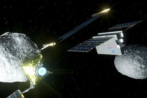
The Light Italian Cubesat for Imaging of Asteroids, LICIACube, is a 6U CubeSat mission of the Italian Space Agency (ASI), developed and operated by the Italian company Argotec, under ASI coordination and with the contribution of several Italian Research Institutions. LICIACube participated in the NASA’s planetary defense DART mission, which tested the effectiveness of kinetic deflectors by impacting into the secondary asteroid of the Didymos system, Dimorphos.
LICIACube provided unique pictures of the post-impact scene, acquired during a single high-speed flyby of the Didymos asteroid system, supporting the energy exchange investigations.
On September 11, 2022, the CubeSat was released from the DART piggyback dispenser and started its independent approach to the system. Few hours later, the navigation operations of LICIACube kicked-off. For the following 15 days, different orbital and desaturation manoeuvres were designed and executed, leading LICIACube towards the predefined location to observe DART’s impact on Dimorphos. On September 26, 2022, about 168 seconds after DART’s impact, LICIACube flew by the asteroid at ~58 km and ~6.1 km/sec, capturing images of the impact, the ejecta plume and the non sun-lit side of Dimorphos, becoming the first CubeSat to flyby an asteroid in deep space. After the impact, the spacecraft continued on its trajectory while downloading the acquired images to the Mission Control Centre until December 23, 2022, when following an ASI decision, the spacecraft was commanded to execute the end-of-life procedure, and subsequently the end of mission was declared.
The navigation strategy of LICIACube relied on classical two-way radiometric data, range and range-rate observables, and has been performed independently by both the University of Bologna (UNIBO) and the JPL, using JPL’s orbit determination software MONTE. This work discusses the navigation processes performed by the UNIBO flight dynamics team in order to support efficient and accurate navigation operations. In addition, it covers the challenges and the lessons learned on deep space CubeSat navigation
-
.
-
